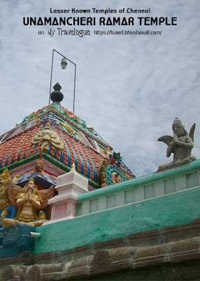
IN SEARCH OF UNAMANCHERI TEMPLE
After Mambakkam Murugatheeswarar Temple and Kandigai Quarry, I continued to hunt for Unaimancheri Temple. First I found Kolapakkam and then enquired locally for Unaimancheri and ventured in the road that the locals directed me. And almost at the end of the village, I spotted the temple.
RENOVATION OF UNAMANCHERI RAMAR TEMPLE
A temple that was pretty new and multi color paints and cement reinforcement. That really made me wonder if it was the temple I came in search of. Some construction work was going on in the neighbouring house and I enquired again and again if this was the Ramar Temple of Unaimancheri and they replied in affirmative.
I should say I was disheartened by the new look given to the ancient temple. It was closed and on enquiry I came to know that the temples opens only early in the morning.
HISTORY, ARCHITECTURE & SCULPTURES OF UNAMANCHERI RAMAR TEMPLE
However I could access the Maha Mandapam. The solid granite of which the basic structure is made of, is the standing proof that the temple is ancient. It had a few pillars and some beautiful reliefs on these sculptures.
One of the reliefs here in the temple wall is of a Varaha (Wild Pig) and a standing Sword. This is a sure shot evidence that the temple belongs to the Vijayanagara Empire. Well, this was built in the 16th C by Achuta Raya, who was the brother of Krishna Deva Raya. Yes, I did spot a couple of inscriptions. And the steps of the temple had the mythical creature Yaali on either sides.
I came around the temple and I spotted a temple pond behind the temple. I would venture once again early morning, to Unamancheri Ramar Temple, one of the lesser-known temples near Tambaram to see how the interiors of the temple is. Well, only this I wished was they had taken the services of Archeologists or Art Historians before they renovated this, so they could have retained the ancient feel as it was...
HOW TO REACH UNAMANCHERI RAMAR TEMPLE
On Google Maps: Unamancheri Ramar Temple
The temple is located at the extreme end of the Unanmacheri Village.
From Tambaram to Unamancheri: 13km via Perungalathur, Vandalur and then on Vandalur - Kelambakkam Road. Right turn at Unamancheri near Kolapakkam.
From Medavakkam to Unamancheri: 21km on Medavakkam - Mambakkam Road, then turn towards Vandalur at Mambakkam. Left turn at Unamancheri near Kolapakkam.


Wow amazing place , nice write up . Thanks for sharing .
ReplyDeleteThose steps are beautiful!And I'm not a fan of the new multicolored structure too,takes the old world charm away.
ReplyDeleteInteresting unknown location. Thanks for sharing.. Will try to visit sometime..!
ReplyDeleteThis comment has been removed by a blog administrator.
ReplyDeleteAmazing photos!!
ReplyDeletehi bhushavali
ReplyDeleteentirely different shades of traditional temple shading...
nice historical info...
thanks for sharing....
"HAPPY ONAM TO YOUR & YOUR FAMILY"
@Team G,
ReplyDeleteThanks dears... :)
@Soumi,
Yeah I too love the steps... Indeed its so sad that these heritage sites are renovated without consulting archaeologists...:(
@Sridharan,
Sure. Do visit and blog abt it. I'd love to know your view of the temple... :)
@Groupdmt,
Thanks dear... :)
@Phivos,
Thanks love... :)
@Krishna,
Thanks a lot dear... :)
:) Nice details. TFS!
ReplyDeleteThanks Ramjee! :)
ReplyDeleteIt should be Achutaraya, may be typing error. pl. note
ReplyDeleteTHANKS .WITH THE HELP OF THIS WEBSITE I WAS ABLE TO FIND MY ANCESTRAL AMMAN TEMPLE LOCATED NEAR IT
ReplyDeleteTHANKS I WAS ABLE TO LOCATE MY ANCESTRAL AMMAN TEMPLE (KULATHAIVAM)
ReplyDeleteGlad you were able to find your ancestral amman temple! :)
ReplyDeleteI'm immensely happy!!!
Hey there!
ReplyDeleteThank you so much for this post. I'm a local resident and was completely ignorant of the antiquity of the temple. This has inspired me to learn more about our temple.